


2023-02-23_20h53m41_Sart Dames Avelines-2023-02-projet

sarriette
User


--
Difficulty : Medium

FREE GPS app for hiking
 SityTrail
IGN / Geographical institutes
SityTrail Plus
The world is yours!
About
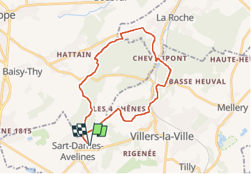
Trail Walking of 14 km to be discovered at Wallonia, Walloon Brabant, Villers-la-Ville. This trail is proposed by sarriette.
Description
<p>Type: Marche<br/>Heure de départ: 13:37 21 févr. 2023<br/>Heure d'arrivée: 16:58 21 févr. 2023<br/>Distance: 14,3 km (03:20)<br/>Temps déplacement: 03:12<br/>Vitesse moyenne: 4,28 km/h<br/>Vitesse moyenne mouv.: 4,45 km/h<br/>Vitesse Max.: 33,54 km/h<br/>Altitude minimale: 82 m<br/>Altitude maximale: 152 m<br/>Vitesse de montée: 147 m/h<br/>Vitesse de descente: 138,3 m/h<br/>Gain d'altitude: 207 m<br/>Perte d'altitude: 207 m<br/>Temps de montée: 01:24<br/>Temps de descente: 01:29<br/></p><hr align="center" width="480" style="height: 2px; width: 517px"/>
<p>Type: Marche<br/>Heure de départ: 13:37 21 févr. 2023<br/>Heure d'arrivée: 16:58 21 févr. 2023<br/>Distance: 14 km (03:20)<br/>Temps déplacement: 03:03<br/>Vitesse moyenne: 4,18 km/h<br/>Vitesse moyenne mouv.: 4,57 km/h<br/>Vitesse Max.: 39,06 km/h<br/>Altitude minimale: 81 m<br/>Altitude maximale: 152 m<br/>Vitesse de montée: 247,9 m/h<br/>Vitesse de descente: 253,3 m/h<br/>Gain d'altitude: 274 m<br/>Perte d'altitude: 275 m<br/>Temps de montée: 01:06<br/>Temps de descente: 01:05<br/></p><hr align="center" width="480" style="height: 2px; width: 517px"/>
Positioning
Comments