


BURE SUR YVETTE EN PAPILLON

NUITEVEN
User
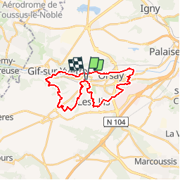

Length
25 km

Max alt
175 m

Uphill gradient
399 m
Km-Effort
30 km

Min alt
52 m

Downhill gradient
401 m
Boucle
Yes
Creation date :
2016-01-25 00:00:00.0
Updated on :
2016-01-25 00:00:00.0
6h26
Difficulty : Easy

FREE GPS app for hiking
 SityTrail
IGN / Geographical institutes
SityTrail Plus
The world is yours!
About
Trail Walking of 25 km to be discovered at Ile-de-France, Essonne, Bures-sur-Yvette. This trail is proposed by NUITEVEN.
Positioning
Country:
France
Region :
Ile-de-France
Department/Province :
Essonne
Municipality :
Bures-sur-Yvette
Location:
Unknown
Start:(Dec)
Start:(UTM)
438439 ; 5393995 (31U) N.
Comments