


chignin

CABERMAT
User

Length
7.6 km

Max alt
528 m

Uphill gradient
230 m
Km-Effort
10.7 km

Min alt
337 m

Downhill gradient
242 m
Boucle
Yes
Creation date :
2023-02-26 09:23:56.126
Updated on :
2023-02-26 12:27:36.781
3h02
Difficulty : Medium

FREE GPS app for hiking
 SityTrail
IGN / Geographical institutes
SityTrail Plus
The world is yours!
About
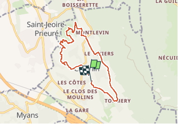
Trail Walking of 7.6 km to be discovered at Auvergne-Rhône-Alpes, Savoy, Chignin. This trail is proposed by CABERMAT.
Positioning
Country:
France
Region :
Auvergne-Rhône-Alpes
Department/Province :
Savoy
Municipality :
Chignin
Location:
Unknown
Start:(Dec)
Start:(UTM)
266370 ; 5045429 (32T) N.
Comments