


T-A516 Fontainebleau-Mont St-Germain

Jack-94
User
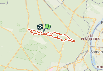

Length
12.2 km

Max alt
149 m

Uphill gradient
205 m
Km-Effort
15 km

Min alt
85 m

Downhill gradient
204 m
Boucle
Yes
Creation date :
2023-02-26 08:42:32.472
Updated on :
2023-02-26 18:10:41.181
5h45
Difficulty : Difficult

FREE GPS app for hiking
 SityTrail
IGN / Geographical institutes
SityTrail Plus
The world is yours!
About
Trail Walking of 12.2 km to be discovered at Ile-de-France, Seine-et-Marne, Fontainebleau. This trail is proposed by Jack-94.
Positioning
Country:
France
Region :
Ile-de-France
Department/Province :
Seine-et-Marne
Municipality :
Fontainebleau
Location:
Unknown
Start:(Dec)
Start:(UTM)
477023 ; 5365320 (31U) N.
Comments