


Vars 1

fb30
User
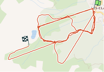

Length
18.8 km

Max alt
2351 m

Uphill gradient
1960 m
Km-Effort
44 km

Min alt
1858 m

Downhill gradient
1606 m
Boucle
No
Creation date :
2023-02-27 10:09:07.0
Updated on :
2023-02-27 15:25:27.574
2h35
Difficulty : Easy

FREE GPS app for hiking
 SityTrail
IGN / Geographical institutes
SityTrail Plus
The world is yours!
About
Trail Alpine skiing of 18.8 km to be discovered at Provence-Alpes-Côte d'Azur, Hautes-Alpes, Vars. This trail is proposed by fb30.
Positioning
Country:
France
Region :
Provence-Alpes-Côte d'Azur
Department/Province :
Hautes-Alpes
Municipality :
Vars
Location:
Unknown
Start:(Dec)
Start:(UTM)
315756 ; 4938067 (32T) N.
Comments