


rando du 7 mars 2023

mimimartine
User

Length
18.4 km

Max alt
123 m

Uphill gradient
116 m
Km-Effort
19.9 km

Min alt
92 m

Downhill gradient
118 m
Boucle
Yes
Creation date :
2023-02-28 09:20:42.341
Updated on :
2023-02-28 09:22:48.385
4h31
Difficulty : Easy

FREE GPS app for hiking
 SityTrail
IGN / Geographical institutes
SityTrail Plus
The world is yours!
About
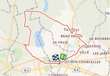
Trail On foot of 18.4 km to be discovered at Ile-de-France, Seine-et-Marne, Tournan-en-Brie. This trail is proposed by mimimartine.
Positioning
Country:
France
Region :
Ile-de-France
Department/Province :
Seine-et-Marne
Municipality :
Tournan-en-Brie
Location:
Unknown
Start:(Dec)
Start:(UTM)
482384 ; 5398443 (31U) N.
Comments