


2023-02-28_18h34m14_Sermaise_marche20230228094552

jpcccb
User
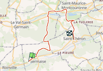

Length
12.7 km

Max alt
169 m

Uphill gradient
267 m
Km-Effort
16.2 km

Min alt
60 m

Downhill gradient
261 m
Boucle
No
Creation date :
2023-02-28 17:34:18.768
Updated on :
2023-05-09 12:54:41.675
3h41
Difficulty : Difficult

FREE GPS app for hiking
 SityTrail
IGN / Geographical institutes
SityTrail Plus
The world is yours!
About
Trail Walking of 12.7 km to be discovered at Ile-de-France, Essonne, Sermaise. This trail is proposed by jpcccb.
Positioning
Country:
France
Region :
Ile-de-France
Department/Province :
Essonne
Municipality :
Sermaise
Location:
Unknown
Start:(Dec)
Start:(UTM)
431289 ; 5376267 (31U) N.
Comments