


Morsang sur Seine 23 km

jeanmarcMasson
User GUIDE
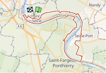

Length
24 km

Max alt
103 m

Uphill gradient
289 m
Km-Effort
27 km

Min alt
31 m

Downhill gradient
288 m
Boucle
Yes
Creation date :
2023-03-01 08:42:22.519
Updated on :
2023-03-01 14:48:28.056
4h53
Difficulty : Very difficult

FREE GPS app for hiking
 SityTrail
IGN / Geographical institutes
SityTrail Plus
The world is yours!
About
Trail Walking of 24 km to be discovered at Ile-de-France, Essonne, Morsang-sur-Seine. This trail is proposed by jeanmarcMasson.
Positioning
Country:
France
Region :
Ile-de-France
Department/Province :
Essonne
Municipality :
Morsang-sur-Seine
Location:
Unknown
Start:(Dec)
Start:(UTM)
462645 ; 5380056 (31U) N.
Comments