


reconnaissance

randolea
User
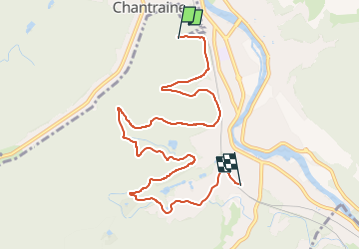

Length
8.9 km

Max alt
449 m

Uphill gradient
191 m
Km-Effort
11.5 km

Min alt
348 m

Downhill gradient
208 m
Boucle
No
Creation date :
2023-03-01 13:48:12.685
Updated on :
2023-03-01 15:11:37.253
58m
Difficulty : Medium

FREE GPS app for hiking
 SityTrail
IGN / Geographical institutes
SityTrail Plus
The world is yours!
About
Trail Mountain bike of 8.9 km to be discovered at Grand Est, Vosges, Épinal. This trail is proposed by randolea.
Positioning
Country:
France
Region :
Grand Est
Department/Province :
Vosges
Municipality :
Épinal
Location:
Unknown
Start:(Dec)
Start:(UTM)
309720 ; 5337755 (32U) N.
Comments
Très bonne précision même sans les données