


Eybens - Fort du Mûrier

maupassant38
User
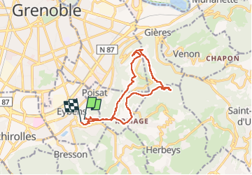

Length
14.2 km

Max alt
701 m

Uphill gradient
624 m
Km-Effort
23 km

Min alt
241 m

Downhill gradient
642 m
Boucle
Yes
Creation date :
2023-02-27 09:21:31.935
Updated on :
2023-03-01 16:03:42.78
3h27
Difficulty : Medium

FREE GPS app for hiking
 SityTrail
IGN / Geographical institutes
SityTrail Plus
The world is yours!
About
Trail Walking of 14.2 km to be discovered at Auvergne-Rhône-Alpes, Isère, Eybens. This trail is proposed by maupassant38.
Positioning
Country:
France
Region :
Auvergne-Rhône-Alpes
Department/Province :
Isère
Municipality :
Eybens
Location:
Unknown
Start:(Dec)
Start:(UTM)
716510 ; 5003251 (31T) N.
Comments