


maron

noelphil
User
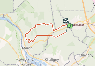

Length
12 km

Max alt
413 m

Uphill gradient
166 m
Km-Effort
14.3 km

Min alt
282 m

Downhill gradient
193 m
Boucle
No
Creation date :
2022-12-27 12:37:25.866
Updated on :
2023-03-01 16:30:53.001
3h03
Difficulty : Difficult

FREE GPS app for hiking
 SityTrail
IGN / Geographical institutes
SityTrail Plus
The world is yours!
About
Trail Walking of 12 km to be discovered at Grand Est, Meurthe-et-Moselle, Chaligny. This trail is proposed by noelphil.
Positioning
Country:
France
Region :
Grand Est
Department/Province :
Meurthe-et-Moselle
Municipality :
Chaligny
Location:
Unknown
Start:(Dec)
Start:(UTM)
286349 ; 5392564 (32U) N.
Comments