


chaligny

noelphil
User
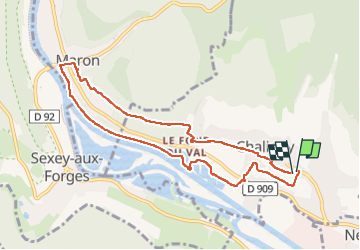

Length
8.3 km

Max alt
279 m

Uphill gradient
143 m
Km-Effort
10.2 km

Min alt
210 m

Downhill gradient
139 m
Boucle
Yes
Creation date :
2023-02-26 13:32:51.547
Updated on :
2023-03-01 16:31:00.607
2h12
Difficulty : Medium

FREE GPS app for hiking
 SityTrail
IGN / Geographical institutes
SityTrail Plus
The world is yours!
About
Trail Walking of 8.3 km to be discovered at Grand Est, Meurthe-et-Moselle, Chaligny. This trail is proposed by noelphil.
Positioning
Country:
France
Region :
Grand Est
Department/Province :
Meurthe-et-Moselle
Municipality :
Chaligny
Location:
Unknown
Start:(Dec)
Start:(UTM)
285249 ; 5389629 (32U) N.
Comments