


rivière 01 03 23

Wernerch
User
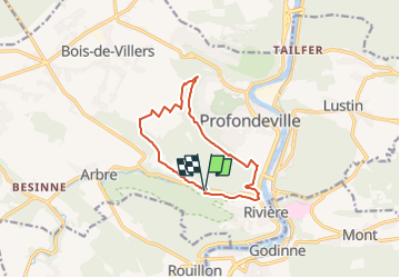

Length
10.1 km

Max alt
269 m

Uphill gradient
259 m
Km-Effort
13.5 km

Min alt
87 m

Downhill gradient
256 m
Boucle
Yes
Creation date :
2023-03-01 18:09:42.764
Updated on :
2023-03-01 18:12:56.267
3h04
Difficulty : Easy

FREE GPS app for hiking
 SityTrail
IGN / Geographical institutes
SityTrail Plus
The world is yours!
About
Trail On foot of 10.1 km to be discovered at Wallonia, Namur, Profondeville. This trail is proposed by Wernerch.
Positioning
Country:
Belgium
Region :
Wallonia
Department/Province :
Namur
Municipality :
Profondeville
Location:
Profondeville
Start:(Dec)
Start:(UTM)
631839 ; 5580559 (31U) N.
Comments