


R2-Fontainebleau-Rocher-des-Princes

Jack-94
User
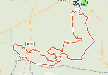

Length
16 km

Max alt
139 m

Uphill gradient
333 m
Km-Effort
20 km

Min alt
90 m

Downhill gradient
330 m
Boucle
Yes
Creation date :
2023-03-01 20:02:52.724
Updated on :
2023-03-01 20:34:38.746
6h03
Difficulty : Very difficult

FREE GPS app for hiking
 SityTrail
IGN / Geographical institutes
SityTrail Plus
The world is yours!
About
Trail Walking of 16 km to be discovered at Ile-de-France, Seine-et-Marne, Fontainebleau. This trail is proposed by Jack-94.
Positioning
Country:
France
Region :
Ile-de-France
Department/Province :
Seine-et-Marne
Municipality :
Fontainebleau
Location:
Unknown
Start:(Dec)
Start:(UTM)
481432 ; 5357768 (31U) N.
Comments