


parc relais

canal
User
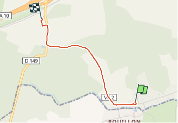

Length
2.1 km

Max alt
159 m

Uphill gradient
40 m
Km-Effort
2.7 km

Min alt
118 m

Downhill gradient
37 m
Boucle
No
Creation date :
2023-03-02 13:48:10.34
Updated on :
2023-03-02 14:20:20.765
31m
Difficulty : Easy

FREE GPS app for hiking
 SityTrail
IGN / Geographical institutes
SityTrail Plus
The world is yours!
About
Trail Walking of 2.1 km to be discovered at Ile-de-France, Yvelines, Longvilliers. This trail is proposed by canal.
Positioning
Country:
France
Region :
Ile-de-France
Department/Province :
Yvelines
Municipality :
Longvilliers
Location:
Unknown
Start:(Dec)
Start:(UTM)
426436 ; 5378628 (31U) N.
Comments