


La Haye Aubrée - Le chemin aux Anes- Version 03-04

MichelRando7656
User
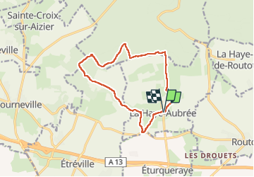

Length
12.7 km

Max alt
134 m

Uphill gradient
161 m
Km-Effort
14.8 km

Min alt
68 m

Downhill gradient
159 m
Boucle
Yes
Creation date :
2023-03-04 08:01:53.077
Updated on :
2023-03-04 11:21:47.663
3h19
Difficulty : Difficult

FREE GPS app for hiking
 SityTrail
IGN / Geographical institutes
SityTrail Plus
The world is yours!
About
Trail Walking of 12.7 km to be discovered at Normandy, Eure, La Haye-Aubrée. This trail is proposed by MichelRando7656.
Description
Chemins et petites routes
Photos


Positioning
Country:
France
Region :
Normandy
Department/Province :
Eure
Municipality :
La Haye-Aubrée
Location:
Unknown
Start:(Dec)
Start:(UTM)
332549 ; 5473148 (31U) N.
Comments