


kirbon

jlnessy
User
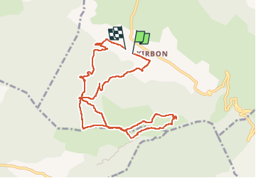

Length
10.9 km

Max alt
691 m

Uphill gradient
334 m
Km-Effort
15.4 km

Min alt
379 m

Downhill gradient
338 m
Boucle
Yes
Creation date :
2022-11-22 09:09:28.797
Updated on :
2023-03-05 14:23:48.252
5h07
Difficulty : Medium

FREE GPS app for hiking
 SityTrail
IGN / Geographical institutes
SityTrail Plus
The world is yours!
About
Trail Walking of 10.9 km to be discovered at Provence-Alpes-Côte d'Azur, Bouches-du-Rhône, Trets. This trail is proposed by jlnessy.
Positioning
Country:
France
Region :
Provence-Alpes-Côte d'Azur
Department/Province :
Bouches-du-Rhône
Municipality :
Trets
Location:
Unknown
Start:(Dec)
Start:(UTM)
715519 ; 4810198 (31T) N.
Comments