


TERNEZE-05-03-23

papou73
User
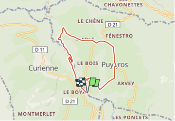

Length
6.6 km

Max alt
778 m

Uphill gradient
251 m
Km-Effort
10 km

Min alt
556 m

Downhill gradient
250 m
Boucle
Yes
Creation date :
2023-03-05 14:29:52.666
Updated on :
2023-03-05 14:31:32.898
2h15
Difficulty : Medium

FREE GPS app for hiking
 SityTrail
IGN / Geographical institutes
SityTrail Plus
The world is yours!
About
Trail Walking of 6.6 km to be discovered at Auvergne-Rhône-Alpes, Savoy, Puygros. This trail is proposed by papou73.
Positioning
Country:
France
Region :
Auvergne-Rhône-Alpes
Department/Province :
Savoy
Municipality :
Puygros
Location:
Unknown
Start:(Dec)
Start:(UTM)
267803 ; 5049475 (32T) N.
Comments