


Les passerelles du Monteynard en aller-retour depuis Mayres-Savel - 05 mars 2023

morganee
User
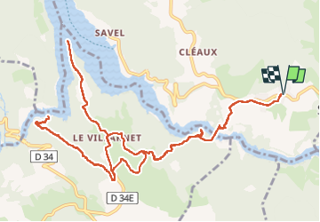

Length
17.3 km

Max alt
693 m

Uphill gradient
829 m
Km-Effort
28 km

Min alt
470 m

Downhill gradient
830 m
Boucle
Yes
Creation date :
2023-03-05 09:21:18.678
Updated on :
2023-03-05 16:15:51.963
6h00
Difficulty : Medium

FREE GPS app for hiking
 SityTrail
IGN / Geographical institutes
SityTrail Plus
The world is yours!
About
Trail Walking of 17.3 km to be discovered at Auvergne-Rhône-Alpes, Isère, Mayres-Savel. This trail is proposed by morganee.
Positioning
Country:
France
Region :
Auvergne-Rhône-Alpes
Department/Province :
Isère
Municipality :
Mayres-Savel
Location:
Unknown
Start:(Dec)
Start:(UTM)
715001 ; 4972587 (31T) N.
Comments