


T - Gometz-le-Châtel

Jack-94
User
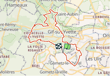

Length
19.5 km

Max alt
174 m

Uphill gradient
601 m
Km-Effort
27 km

Min alt
65 m

Downhill gradient
594 m
Boucle
Yes
Creation date :
2023-03-05 08:18:50.234
Updated on :
2023-03-10 14:09:43.324
6h07
Difficulty : Very difficult

FREE GPS app for hiking
 SityTrail
IGN / Geographical institutes
SityTrail Plus
The world is yours!
About
Trail Walking of 19.5 km to be discovered at Ile-de-France, Essonne, Gif-sur-Yvette. This trail is proposed by Jack-94.
Positioning
Country:
France
Region :
Ile-de-France
Department/Province :
Essonne
Municipality :
Gif-sur-Yvette
Location:
Unknown
Start:(Dec)
Start:(UTM)
436415 ; 5392896 (31U) N.
Comments