


valaurie

losjo
User
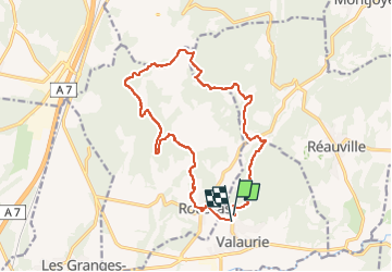

Length
16.9 km

Max alt
380 m

Uphill gradient
422 m
Km-Effort
23 km

Min alt
111 m

Downhill gradient
434 m
Boucle
Yes
Creation date :
2023-03-05 19:04:23.124
Updated on :
2023-03-05 19:04:58.823
5h08
Difficulty : Very difficult

FREE GPS app for hiking
 SityTrail
IGN / Geographical institutes
SityTrail Plus
The world is yours!
About
Trail Walking of 16.9 km to be discovered at Auvergne-Rhône-Alpes, Drôme, Valaurie. This trail is proposed by losjo.
Description
rando marche
Positioning
Country:
France
Region :
Auvergne-Rhône-Alpes
Department/Province :
Drôme
Municipality :
Valaurie
Location:
Unknown
Start:(Dec)
Start:(UTM)
644129 ; 4921068 (31T) N.
Comments