


Presqu’île Casteljau

giovannoni
User
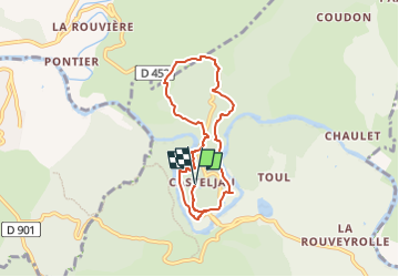

Length
7.2 km

Max alt
238 m

Uphill gradient
267 m
Km-Effort
10.8 km

Min alt
123 m

Downhill gradient
267 m
Boucle
Yes
Creation date :
2023-03-06 08:21:02.0
Updated on :
2023-03-06 08:21:03.986
2h26
Difficulty : Medium

FREE GPS app for hiking
 SityTrail
IGN / Geographical institutes
SityTrail Plus
The world is yours!
About
Trail Walking of 7.2 km to be discovered at Auvergne-Rhône-Alpes, Ardèche, Berrias-et-Casteljau. This trail is proposed by giovannoni.
Positioning
Country:
France
Region :
Auvergne-Rhône-Alpes
Department/Province :
Ardèche
Municipality :
Berrias-et-Casteljau
Location:
Casteljau
Start:(Dec)
Start:(UTM)
595193 ; 4917006 (31T) N.
Comments