


A52S-TR1-Mennecy

Jack-94
User
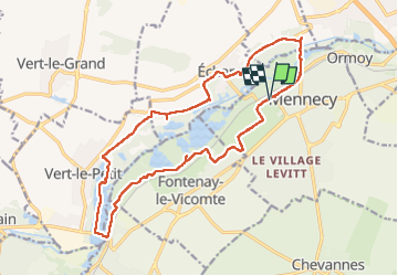

Length
17.8 km

Max alt
88 m

Uphill gradient
162 m
Km-Effort
19.9 km

Min alt
43 m

Downhill gradient
160 m
Boucle
Yes
Creation date :
2023-03-06 09:23:25.489
Updated on :
2023-03-10 10:25:42.783
5h28
Difficulty : Very difficult

FREE GPS app for hiking
 SityTrail
IGN / Geographical institutes
SityTrail Plus
The world is yours!
About
Trail Walking of 17.8 km to be discovered at Ile-de-France, Essonne, Mennecy. This trail is proposed by Jack-94.
Positioning
Country:
France
Region :
Ile-de-France
Department/Province :
Essonne
Municipality :
Mennecy
Location:
Unknown
Start:(Dec)
Start:(UTM)
457538 ; 5379427 (31U) N.
Comments