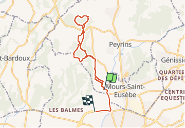
Étang de Chalayre , bois des Ussiaux

alinetpierre
User

Length
15 km

Max alt
325 m

Uphill gradient
307 m
Km-Effort
19.1 km

Min alt
167 m

Downhill gradient
315 m
Boucle
No
Creation date :
2023-03-06 12:40:55.0
Updated on :
2023-03-06 16:06:17.135
3h04
Difficulty : Easy

FREE GPS app for hiking
 SityTrail
IGN / Geographical institutes
SityTrail Plus
The world is yours!
About
Trail Walking of 15 km to be discovered at Auvergne-Rhône-Alpes, Drôme, Peyrins. This trail is proposed by alinetpierre.
Description
Très belle randonnée dans la Drôme des collines
Positioning
Country:
France
Region :
Auvergne-Rhône-Alpes
Department/Province :
Drôme
Municipality :
Peyrins
Location:
Unknown
Start:(Dec)
Start:(UTM)
660373 ; 4992825 (31T) N.
Comments