


vascoeuil

dedejojo
User
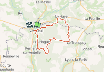

Length
27 km

Max alt
185 m

Uphill gradient
484 m
Km-Effort
33 km

Min alt
52 m

Downhill gradient
484 m
Boucle
Yes
Creation date :
2023-03-07 09:46:02.719
Updated on :
2023-03-07 09:47:19.865
7h30
Difficulty : Difficult
7h30
Difficulty : Very difficult

FREE GPS app for hiking
 SityTrail
IGN / Geographical institutes
SityTrail Plus
The world is yours!
About
Trail On foot of 27 km to be discovered at Normandy, Eure, Vascœuil. This trail is proposed by dedejojo.
Positioning
Country:
France
Region :
Normandy
Department/Province :
Eure
Municipality :
Vascœuil
Location:
Unknown
Start:(Dec)
Start:(UTM)
382277 ; 5477986 (31U) N.
Comments