


lalevade

raab
User
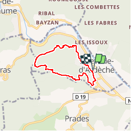

Length
5.6 km

Max alt
471 m

Uphill gradient
200 m
Km-Effort
8.3 km

Min alt
268 m

Downhill gradient
200 m
Boucle
Yes
Creation date :
2018-07-30 16:23:40.109
Updated on :
2018-07-30 16:23:40.117
1h45
Difficulty : Medium

FREE GPS app for hiking
 SityTrail
IGN / Geographical institutes
SityTrail Plus
The world is yours!
About
Trail Walking of 5.6 km to be discovered at Auvergne-Rhône-Alpes, Ardèche, Lalevade-d'Ardèche. This trail is proposed by raab.
Positioning
Country:
France
Region :
Auvergne-Rhône-Alpes
Department/Province :
Ardèche
Municipality :
Lalevade-d'Ardèche
Location:
Unknown
Start:(Dec)
Start:(UTM)
604793 ; 4944890 (31T) N.
Comments