


Bure 10-03-23

libinsport
User
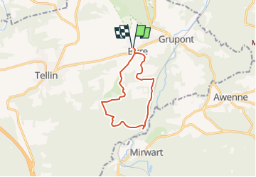

Length
9.3 km

Max alt
401 m

Uphill gradient
269 m
Km-Effort
12.9 km

Min alt
246 m

Downhill gradient
269 m
Boucle
Yes
Creation date :
2023-03-07 12:51:24.158
Updated on :
2023-03-07 12:52:06.708
2h55
Difficulty : Difficult

FREE GPS app for hiking
 SityTrail
IGN / Geographical institutes
SityTrail Plus
The world is yours!
About
Trail Walking of 9.3 km to be discovered at Wallonia, Luxembourg, Tellin. This trail is proposed by libinsport.
Positioning
Country:
Belgium
Region :
Wallonia
Department/Province :
Luxembourg
Municipality :
Tellin
Location:
Unknown
Start:(Dec)
Start:(UTM)
661569 ; 5551014 (31U) N.
Comments