


MALPASSET/ MAGAIL

Michel DUBOIS
User
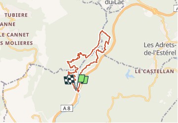

Length
14.6 km

Max alt
155 m

Uphill gradient
352 m
Km-Effort
19.2 km

Min alt
38 m

Downhill gradient
351 m
Boucle
Yes
Creation date :
2023-03-07 14:53:16.991
Updated on :
2023-03-07 14:54:20.857
4h22
Difficulty : Easy

FREE GPS app for hiking
 SityTrail
IGN / Geographical institutes
SityTrail Plus
The world is yours!
About
Trail Walking of 14.6 km to be discovered at Provence-Alpes-Côte d'Azur, Var, Fréjus. This trail is proposed by Michel DUBOIS.
Positioning
Country:
France
Region :
Provence-Alpes-Côte d'Azur
Department/Province :
Var
Municipality :
Fréjus
Location:
Unknown
Start:(Dec)
Start:(UTM)
318634 ; 4819299 (32T) N.
Comments