


Potigny

jacqueline L
User
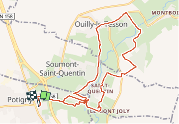

Length
12.3 km

Max alt
168 m

Uphill gradient
215 m
Km-Effort
15.1 km

Min alt
80 m

Downhill gradient
216 m
Boucle
Yes
Creation date :
2023-03-07 12:40:46.0
Updated on :
2023-03-07 16:57:10.191
4h15
Difficulty : Difficult

FREE GPS app for hiking
 SityTrail
IGN / Geographical institutes
SityTrail Plus
The world is yours!
About
Trail Walking of 12.3 km to be discovered at Normandy, Calvados, Potigny. This trail is proposed by jacqueline L.
Positioning
Country:
France
Region :
Normandy
Department/Province :
Calvados
Municipality :
Potigny
Location:
Unknown
Start:(Dec)
Start:(UTM)
701912 ; 5427779 (30U) N.
Comments