


A517-TR1-3-Forêt-de-la-Roche-Turpin

Jack-94
User
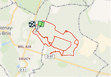

Length
13.7 km

Max alt
168 m

Uphill gradient
230 m
Km-Effort
16.8 km

Min alt
112 m

Downhill gradient
228 m
Boucle
Yes
Creation date :
2023-03-07 13:05:40.112
Updated on :
2023-03-10 10:31:17.83
4h22
Difficulty : Difficult

FREE GPS app for hiking
 SityTrail
IGN / Geographical institutes
SityTrail Plus
The world is yours!
About
Trail Walking of 13.7 km to be discovered at Ile-de-France, Essonne, Bruyères-le-Châtel. This trail is proposed by Jack-94.
Positioning
Country:
France
Region :
Ile-de-France
Department/Province :
Essonne
Municipality :
Bruyères-le-Châtel
Location:
Unknown
Start:(Dec)
Start:(UTM)
439112 ; 5385447 (31U) N.
Comments