


Charbonnières 11km

janussity
User
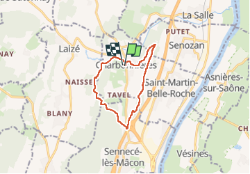

Length
10.6 km

Max alt
280 m

Uphill gradient
170 m
Km-Effort
12.9 km

Min alt
189 m

Downhill gradient
174 m
Boucle
Yes
Creation date :
2023-03-06 12:58:25.672
Updated on :
2023-03-08 15:15:03.712
2h28
Difficulty : Medium

FREE GPS app for hiking
 SityTrail
IGN / Geographical institutes
SityTrail Plus
The world is yours!
About
Trail Walking of 10.6 km to be discovered at Bourgogne-Franche-Comté, Saône-et-Loire, Charbonnières. This trail is proposed by janussity.
Description
belle rando, frais ensoleillée
Positioning
Country:
France
Region :
Bourgogne-Franche-Comté
Department/Province :
Saône-et-Loire
Municipality :
Charbonnières
Location:
Unknown
Start:(Dec)
Start:(UTM)
640955 ; 5138979 (31T) N.
Comments