


2023-03-08_20h27m09_1678303622294_J Ronquerolle bois la tour du Lay

avdem
User
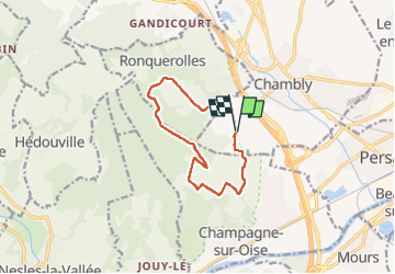

Length
10.1 km

Max alt
174 m

Uphill gradient
153 m
Km-Effort
12.2 km

Min alt
53 m

Downhill gradient
156 m
Boucle
Yes
Creation date :
2023-03-08 19:27:11.017
Updated on :
2023-03-08 19:27:13.812

FREE GPS app for hiking
 SityTrail
IGN / Geographical institutes
SityTrail Plus
The world is yours!
About
Trail of 10.1 km to be discovered at Hauts-de-France, Oise, Chambly. This trail is proposed by avdem.
Positioning
Country:
France
Region :
Hauts-de-France
Department/Province :
Oise
Municipality :
Chambly
Location:
Unknown
Start:(Dec)
Start:(UTM)
443870 ; 5445117 (31U) N.
Comments