


rando balazuc sportive

raab
User
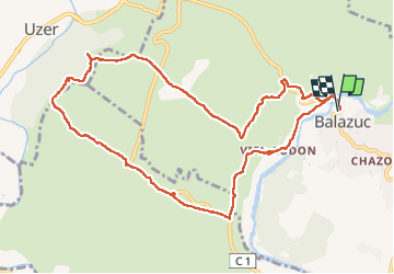

Length
11.8 km

Max alt
331 m

Uphill gradient
353 m
Km-Effort
16.5 km

Min alt
129 m

Downhill gradient
353 m
Boucle
Yes
Creation date :
2023-03-09 08:20:22.995
Updated on :
2023-03-09 13:37:10.989
3h30
Difficulty : Difficult

FREE GPS app for hiking
 SityTrail
IGN / Geographical institutes
SityTrail Plus
The world is yours!
About
Trail Walking of 11.8 km to be discovered at Auvergne-Rhône-Alpes, Ardèche, Balazuc. This trail is proposed by raab.
Positioning
Country:
France
Region :
Auvergne-Rhône-Alpes
Department/Province :
Ardèche
Municipality :
Balazuc
Location:
Unknown
Start:(Dec)
Start:(UTM)
609052 ; 4929486 (31T) N.
Comments