


vauvert

Dupuybadonniere
User
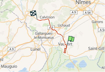

Length
28 km

Max alt
87 m

Uphill gradient
204 m
Km-Effort
30 km

Min alt
10 m

Downhill gradient
197 m
Boucle
No
Creation date :
2023-03-10 12:53:48.351
Updated on :
2023-03-10 15:21:19.747
2h19
Difficulty : Very difficult

FREE GPS app for hiking
 SityTrail
IGN / Geographical institutes
SityTrail Plus
The world is yours!
About
Trail Walking of 28 km to be discovered at Occitania, Gard, Vauvert. This trail is proposed by Dupuybadonniere.
Positioning
Country:
France
Region :
Occitania
Department/Province :
Gard
Municipality :
Vauvert
Location:
Unknown
Start:(Dec)
Start:(UTM)
603524 ; 4838015 (31T) N.
Comments