


Vesc

raygautier
User
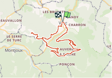

Length
21 km

Max alt
1074 m

Uphill gradient
817 m
Km-Effort
32 km

Min alt
512 m

Downhill gradient
811 m
Boucle
Yes
Creation date :
2023-03-09 07:34:36.0
Updated on :
2023-03-10 15:40:28.229
7h57
Difficulty : Very difficult

FREE GPS app for hiking
 SityTrail
IGN / Geographical institutes
SityTrail Plus
The world is yours!
About
Trail Walking of 21 km to be discovered at Auvergne-Rhône-Alpes, Drôme, Vesc. This trail is proposed by raygautier.
Positioning
Country:
France
Region :
Auvergne-Rhône-Alpes
Department/Province :
Drôme
Municipality :
Vesc
Location:
Unknown
Start:(Dec)
Start:(UTM)
670972 ; 4932148 (31T) N.
Comments