


Volvic Viallard Tourtoule

jeanic63
User
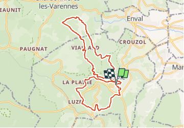

Length
20 km

Max alt
775 m

Uphill gradient
686 m
Km-Effort
29 km

Min alt
479 m

Downhill gradient
686 m
Boucle
Yes
Creation date :
2023-03-10 17:08:58.114
Updated on :
2023-03-20 17:26:11.552
6h39
Difficulty : Medium

FREE GPS app for hiking
 SityTrail
IGN / Geographical institutes
SityTrail Plus
The world is yours!
About
Trail On foot of 20 km to be discovered at Auvergne-Rhône-Alpes, Puy-de-Dôme, Volvic. This trail is proposed by jeanic63.
Description
départ place des moutys a Volvic
Positioning
Country:
France
Region :
Auvergne-Rhône-Alpes
Department/Province :
Puy-de-Dôme
Municipality :
Volvic
Location:
Unknown
Start:(Dec)
Start:(UTM)
502941 ; 5079484 (31T) N.
Comments