


St Martin

raygautier
User
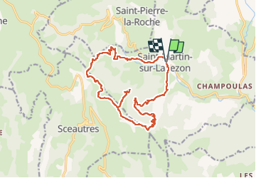

Length
17.7 km

Max alt
699 m

Uphill gradient
575 m
Km-Effort
25 km

Min alt
210 m

Downhill gradient
571 m
Boucle
Yes
Creation date :
2023-03-12 08:10:47.0
Updated on :
2023-03-12 14:42:25.184
6h30
Difficulty : Very difficult

FREE GPS app for hiking
 SityTrail
IGN / Geographical institutes
SityTrail Plus
The world is yours!
About
Trail Walking of 17.7 km to be discovered at Auvergne-Rhône-Alpes, Ardèche, Saint-Martin-sur-Lavezon. This trail is proposed by raygautier.
Positioning
Country:
France
Region :
Auvergne-Rhône-Alpes
Department/Province :
Ardèche
Municipality :
Saint-Martin-sur-Lavezon
Location:
Saint-Martin-le-Supérieur
Start:(Dec)
Start:(UTM)
630934 ; 4944068 (31T) N.
Comments