


Mornans Les Berches

Monjean
User
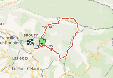

Length
14.8 km

Max alt
1055 m

Uphill gradient
712 m
Km-Effort
24 km

Min alt
420 m

Downhill gradient
729 m
Boucle
No
Creation date :
2023-03-12 08:20:50.105
Updated on :
2023-03-12 18:36:18.086
6h35
Difficulty : Very difficult

FREE GPS app for hiking
 SityTrail
IGN / Geographical institutes
SityTrail Plus
The world is yours!
About
Trail Walking of 14.8 km to be discovered at Auvergne-Rhône-Alpes, Drôme, Mornans. This trail is proposed by Monjean.
Positioning
Country:
France
Region :
Auvergne-Rhône-Alpes
Department/Province :
Drôme
Municipality :
Mornans
Location:
Unknown
Start:(Dec)
Start:(UTM)
668003 ; 4942624 (31T) N.
Comments