


Amédé le vigneron Rabastens

tabouelle
User
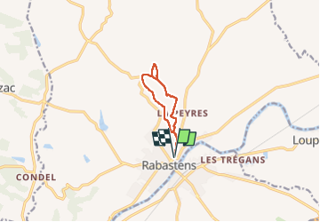

Length
7.8 km

Max alt
218 m

Uphill gradient
109 m
Km-Effort
9.3 km

Min alt
128 m

Downhill gradient
109 m
Boucle
Yes
Creation date :
2022-11-27 10:07:07.058
Updated on :
2023-03-13 14:14:20.056
2h25
Difficulty : Easy

FREE GPS app for hiking
 SityTrail
IGN / Geographical institutes
SityTrail Plus
The world is yours!
About
Trail Walking of 7.8 km to be discovered at Occitania, Tarn, Rabastens. This trail is proposed by tabouelle.
Positioning
Country:
France
Region :
Occitania
Department/Province :
Tarn
Municipality :
Rabastens
Location:
Unknown
Start:(Dec)
Start:(UTM)
397570 ; 4853050 (31T) N.
Comments