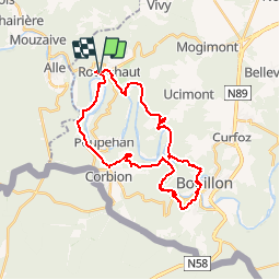
Trail Walking Bouillon - Rochehaut 28 km - Photo
 ramagufa
ramagufa

User

© OpenStreetMap contributors
Length
Length
28 km
Max alt
Max alt
379 m
Uphill gradient
Uphill gradient
1014 m
Km-Effort
Km-Effort  
41 km
Min alt
Min alt
194 m
Downhill gradient
Downhill gradient
1006 m
Boucle
Boucle
Yes
Creation date :
2019-04-16 19:16:52.657
Updated on :
2019-09-18 13:45:50.114

(0 Reviews)

Walking
Walking
8h35
Difficulty : Difficult

Scan this QR Code to open this trail in the SityTrail application

FREE GPS app for hiking

Logo SityTrail SityTrail

IGN / Geographical institutes

Download SityTrail from the App Store Download SityTrail from Google Play

Logo SityTrail SityTrail Plus

The world is yours!

Download SityTrail from the App Store Download SityTrail from Google Play Download SityTrail on Huawei AppGallery

About

Trail Walking of 28 km to be discovered at Wallonia, Luxembourg, Bouillon. This trail is proposed by ramagufa.

Description

Rando corrigée pour la carte IGN belgique (pas la 10.000)
Superbe rando pour ceux qui aiment le dénivelé en Ardennes
Départ du point de vue de Rochehaut
Attention dans les grandes Faloises,on repasser par le bas pour reprendre les échelles, parcours bien sécurisé.

Elevation profile

Positioning

Country:
Belgium
Region :
Wallonia
Department/Province :
Luxembourg
Municipality :
Bouillon
Location:
Rochehaut
Start:(UTM)
643911 ; 5522725 (31U) N.


Close
My subscriptions