


La Chaudière Couspeau

Monjean
User
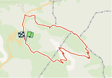

Length
11.4 km

Max alt
1516 m

Uphill gradient
742 m
Km-Effort
21 km

Min alt
832 m

Downhill gradient
743 m
Boucle
Yes
Creation date :
2023-03-16 08:18:26.325
Updated on :
2023-03-16 13:45:13.165
5h25
Difficulty : Very difficult

FREE GPS app for hiking
 SityTrail
IGN / Geographical institutes
SityTrail Plus
The world is yours!
About
Trail Walking of 11.4 km to be discovered at Auvergne-Rhône-Alpes, Drôme, Bézaudun-sur-Bîne. This trail is proposed by Monjean.
Positioning
Country:
France
Region :
Auvergne-Rhône-Alpes
Department/Province :
Drôme
Municipality :
Bézaudun-sur-Bîne
Location:
Unknown
Start:(Dec)
Start:(UTM)
673279 ; 4941854 (31T) N.
Comments