


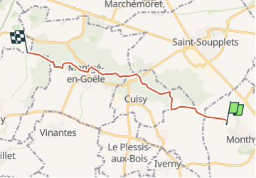
Forêt de Montgé en Goêle 77

GOELERANDO2
User

Length
9 km

Max alt
203 m

Uphill gradient
139 m
Km-Effort
10.9 km

Min alt
103 m

Downhill gradient
151 m
Boucle
No
Creation date :
2023-03-17 17:08:31.559
Updated on :
2023-03-17 17:08:31.559
2h28
Difficulty : Medium

FREE GPS app for hiking
 SityTrail
IGN / Geographical institutes
SityTrail Plus
The world is yours!
About
Trail Walking of 9 km to be discovered at Ile-de-France, Seine-et-Marne, Monthyon. This trail is proposed by GOELERANDO2.
Description
Traversée du bois de Montgé en Goêle depuis le plan d'eau de Monthyon au nord est du village.
Le chemin suit le GR 1
Positioning
Country:
France
Region :
Ile-de-France
Department/Province :
Seine-et-Marne
Municipality :
Monthyon
Location:
Unknown
Start:(Dec)
Start:(UTM)
486556 ; 5428816 (31U) N.
Comments