


20220901-rando_NICOLE_Klingenthal_Châteaux-Ottrott_Mt-St-Odile

nfranche
User
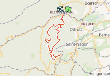

Length
14.5 km

Max alt
773 m

Uphill gradient
566 m
Km-Effort
22 km

Min alt
324 m

Downhill gradient
575 m
Boucle
Yes
Creation date :
2023-03-17 19:44:04.118
Updated on :
2023-04-28 19:29:35.949
5h00
Difficulty : Medium

FREE GPS app for hiking
 SityTrail
IGN / Geographical institutes
SityTrail Plus
The world is yours!
About
Trail Walking of 14.5 km to be discovered at Grand Est, Bas-Rhin, Ottrott. This trail is proposed by nfranche.
Description
File with points/tracks from Locus Map Classic/3.62.1
Positioning
Country:
France
Region :
Grand Est
Department/Province :
Bas-Rhin
Municipality :
Ottrott
Location:
Unknown
Start:(Dec)
Start:(UTM)
382470 ; 5369416 (32U) N.
Comments