


4*4_180423_70kmd

d.rognon
User
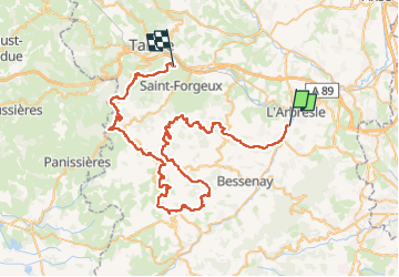

Length
71 km

Max alt
936 m

Uphill gradient
2562 m
Km-Effort
104 km

Min alt
230 m

Downhill gradient
2255 m
Boucle
No
Creation date :
2023-03-18 08:23:35.627
Updated on :
2023-03-19 04:07:18.444
4h15
Difficulty : Easy

FREE GPS app for hiking
 SityTrail
IGN / Geographical institutes
SityTrail Plus
The world is yours!
About
Trail 4x4 of 71 km to be discovered at Auvergne-Rhône-Alpes, Rhône, Éveux. This trail is proposed by d.rognon.
Positioning
Country:
France
Region :
Auvergne-Rhône-Alpes
Department/Province :
Rhône
Municipality :
Éveux
Location:
Unknown
Start:(Dec)
Start:(UTM)
624944 ; 5075714 (31T) N.
Comments