Hierges Mazée Hierges

ameurant
User
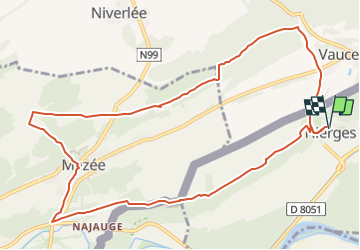

Length
11.2 km

Max alt
244 m

Uphill gradient
256 m
Km-Effort
14.6 km

Min alt
122 m

Downhill gradient
256 m
Boucle
Yes
Creation date :
2023-03-19 10:11:07.104
Updated on :
2023-03-19 12:02:34.47
3h00
Difficulty : Difficult

FREE GPS app for hiking
 SityTrail
IGN / Geographical institutes
SityTrail Plus
The world is yours!
About
Trail Walking of 11.2 km to be discovered at Grand Est, Ardennes, Hierges. This trail is proposed by ameurant.
Description
Avec Henri
Positioning
Country:
France
Region :
Grand Est
Department/Province :
Ardennes
Municipality :
Hierges
Location:
Unknown
Start:(Dec)
Start:(UTM)
624348 ; 5551748 (31U) N.
Comments