


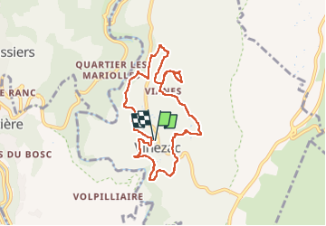
SityTrail - 1100218 - vinezac

Linerou
User

Length
8.6 km

Max alt
288 m

Uphill gradient
191 m
Km-Effort
11.1 km

Min alt
217 m

Downhill gradient
193 m
Boucle
Yes
Creation date :
2023-03-19 23:29:36.248
Updated on :
2023-03-19 23:38:28.752
2h31
Difficulty : Medium

FREE GPS app for hiking
 SityTrail
IGN / Geographical institutes
SityTrail Plus
The world is yours!
About
Trail Walking of 8.6 km to be discovered at Auvergne-Rhône-Alpes, Ardèche, Vinezac. This trail is proposed by Linerou.
Description
Le tour de Vinezac
Positioning
Country:
France
Region :
Auvergne-Rhône-Alpes
Department/Province :
Ardèche
Municipality :
Vinezac
Location:
Unknown
Start:(Dec)
Start:(UTM)
605270 ; 4932667 (31T) N.
Comments