


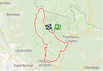
Glandasse Pié Ferré et les Hauts plateaux du Vercors

fred.evin@wanadoo.fr
User

Length
35 km

Max alt
1970 m

Uphill gradient
2405 m
Km-Effort
67 km

Min alt
588 m

Downhill gradient
2397 m
Boucle
No
Creation date :
2023-03-20 17:51:08.812
Updated on :
2023-03-26 13:30:27.527
7h30
Difficulty : Difficult

FREE GPS app for hiking
 SityTrail
IGN / Geographical institutes
SityTrail Plus
The world is yours!
About
Trail Running of 35 km to be discovered at Auvergne-Rhône-Alpes, Drôme, Châtillon-en-Diois. This trail is proposed by fred.evin@wanadoo.fr.
Description
Au départ d'Archianne, boucle de trail passant par Bénevise, Chatillon, Pié Ferré, Jasse de la ville et retour
Positioning
Country:
France
Region :
Auvergne-Rhône-Alpes
Department/Province :
Drôme
Municipality :
Châtillon-en-Diois
Location:
Treschenu-Creyers
Start:(Dec)
Start:(UTM)
698413 ; 4957778 (31T) N.
Comments