


Col du Bougnon la Bastide

Françoise FANTON
User
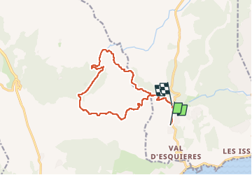

Length
15.2 km

Max alt
288 m

Uphill gradient
413 m
Km-Effort
21 km

Min alt
82 m

Downhill gradient
390 m
Boucle
No
Creation date :
2023-03-21 07:42:29.0
Updated on :
2023-03-21 11:02:48.552
3h19
Difficulty : Unknown

FREE GPS app for hiking
 SityTrail
IGN / Geographical institutes
SityTrail Plus
The world is yours!
About
Trail Nordic walking of 15.2 km to be discovered at Provence-Alpes-Côte d'Azur, Var, Roquebrune-sur-Argens. This trail is proposed by Françoise FANTON.
Description
MN
Positioning
Country:
France
Region :
Provence-Alpes-Côte d'Azur
Department/Province :
Var
Municipality :
Roquebrune-sur-Argens
Location:
Unknown
Start:(Dec)
Start:(UTM)
311361 ; 4803000 (32T) N.
Comments