


Nantes chapelle ste rose 21 03 23

jljacquin
User
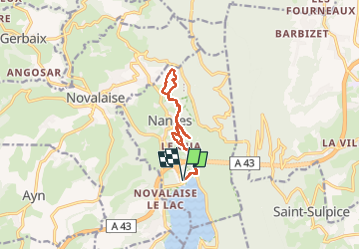

Length
10.1 km

Max alt
671 m

Uphill gradient
382 m
Km-Effort
15.2 km

Min alt
375 m

Downhill gradient
382 m
Boucle
Yes
Creation date :
2023-03-21 12:39:52.3
Updated on :
2023-03-21 16:08:02.184
3h27
Difficulty : Difficult

FREE GPS app for hiking
 SityTrail
IGN / Geographical institutes
SityTrail Plus
The world is yours!
About
Trail Walking of 10.1 km to be discovered at Auvergne-Rhône-Alpes, Savoy, Nances. This trail is proposed by jljacquin.
Positioning
Country:
France
Region :
Auvergne-Rhône-Alpes
Department/Province :
Savoy
Municipality :
Nances
Location:
Unknown
Start:(Dec)
Start:(UTM)
718531 ; 5050660 (31T) N.
Comments