


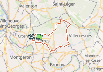
BM YERRES réveillon 12km

jeanmarcMasson
User GUIDE

Length
11.9 km

Max alt
122 m

Uphill gradient
166 m
Km-Effort
14.1 km

Min alt
36 m

Downhill gradient
167 m
Boucle
Yes
Creation date :
2023-03-22 08:15:31.0
Updated on :
2023-03-22 11:03:02.143
2h31
Difficulty : Unknown

FREE GPS app for hiking
 SityTrail
IGN / Geographical institutes
SityTrail Plus
The world is yours!
About
Trail Walking of 11.9 km to be discovered at Ile-de-France, Essonne, Yerres. This trail is proposed by jeanmarcMasson.
Positioning
Country:
France
Region :
Ile-de-France
Department/Province :
Essonne
Municipality :
Yerres
Location:
Unknown
Start:(Dec)
Start:(UTM)
461673 ; 5395895 (31U) N.
Comments